Scale bands specify a map scale in which every single layer is visible on the map.
Setting a scale band for map layers:
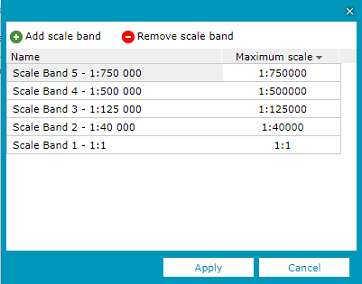
Click Scale bands configuration on the Tools tab.
Add a new scale band. Click Edit and then click Add scale band. Then, enter the name and maximum scale. Having all required scale bands defined click Apply.
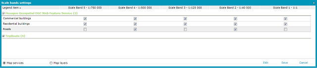
To determine which layers should be displayed in which scales, check or clear the checkboxes next to specific layers and scales.
Sample:
The following scale bands are defined:
1:1
1:40,000
1:125,000
1:500,000
1:750,000
Now let's take a look at the sample Roads feature class.
In the scale band definition, for the Roads class, the scale bands 1:40 000 and 1:500 000 has been selected, so the entire scale band settings are:
1:1 - not selected
1:40,000 - selected
1:125,000 - not selected
1:500,000 - selected
1:750,000 - not selected
In practice, this means that the Roads:
will not be displayed on a scale from 1:1 to 1:3999
will be displayed on a scale from 1:40,000 to 1:124999
will not be displayed on a scale from 1:125000 to 1:499999
will be displayed on a scale from 1:500000 to 1:749 999
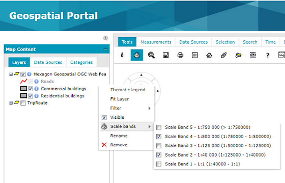
Interval closure for the scale band denominator range is defined as (min, max]
If you take a look at the picture below, showing values of the sample scale ranges listed in the Feature class > Scale bands context menu, you can note that the smaller scale (min value) in the given scale range is this scale at which the object is not displayed anymore. The bigger scale (max value) is that one at which the object is displayed e.g.: for 'Scale Band 1' the 1:1 scale is bigger (max) than 1:40 000 (min).
Options for storing and grouping layers (Map services and Map Layers) are available at the bottom of the Scale bands settings window.
After setting all parameters, click Save to save the changes.
Scale bands functionality allows you to prevent displaying certain layers on certain zoom levels, even if the service would return an appropriate image for this layer, this particular layer will be excluded from the GetMap request.
Scale bands set in Geospatial Portal vs Web service (e.g., WMS/WMTS) scale hints
Scale hints in Web services like WMS/WMTS inform when layers may not return appropriate images. This is used in the portal to display legend items representing those layers in grey (also prevent its presence in the GetMap request). According to the OGC WMS 1.3.0 specification, the scale denominator values are guidelines for clients, not firm limits. Upon receiving a request for a map that is not within the scale denominator range, the server may return a blank map, or may return a portrayal of the Layer that is crowded with features or otherwise poorly suited for display.
Portal scale bands and service scale hints are independent of each other. Scale bands may be used to filter out more than the scale hints do.