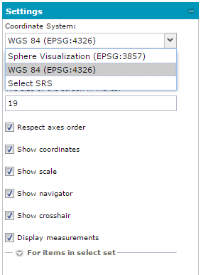
Geospatial Portal displays spatial data in several different coordinate systems. You can change the coordinate system in the sidebar on the Settings tab. By default, the EPSG: 4326 and EPSG: 3857 coordinate systems are available. You can select the SRS from a predefined list or add another one.
To add a new SRS to the Coordinate System list:
From the Coordinate System list, choose Select SRS.
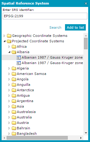
The Spatial Reference Systems dialog box opens and allows you to:
Select the SRS from the tree list.
When the SRS is selected, the Enter SRS identifier field is filled with the appropriate value for the EPSG Code.
Search for a given SRS.
In order to find an SRS, type the EPSG Code into the Enter SRS identifier field and click Search. The search syntax must be as follows: EPSG:nnnn or nnnn, where nnnn is a code number, for example: EPSG:2180 or 2180. When a given SRS is found, the tree will be unfolded, and the appropriate item in the list will be highlighted.
Enter a known SRS if you know the EPSG code for the SRS you want to use.
When adding a known SRS (by providing the code), the warning message that a given SRS may not work properly will be displayed.
Having chosen the coordinate system from the list or having provided the EPSG code in the Enter SRS identifier field, click Add to list. The selected new SRS will appear on the Coordinate System list in the Settings tab and will be applied immediately.
To change the coordinate system:
Select the coordinate system from the Coordinate System drop-down list. The SRS will be applied.
The data can be displayed in the selected coordinate system only when the service that serves this data supports that coordinate system.
When the coordinate system is changed and the currently displayed map area is within the range of the new coordinate system, the map area shown in the new coordinate system remains unchanged.
This behavior is possible only when there is the possibility of a correct conversion between two coordinate systems and when the displayed data range in both coordinate systems is similar. However, when the currently displayed map area is out of the range defined for the new coordinate system, the area of the map will be adjusted to the range defined in the new changed coordinate system.